


Contact Bulusan: lgu.bulusan@yahoo.com
This was a mere visita of Casiguran until 1630, when it separated and became an independent parish, with Fr. Miguel de Sta. Ana, a missionary friar, as head of the new parish. Gate, which was organized by the Franciscans, came under its jurisdiction as a visita.
Since there are no records of Bulusan as a town before 1760, it is assumed that it started functioning as pueblo civil, under the Province of Albay, on this year.
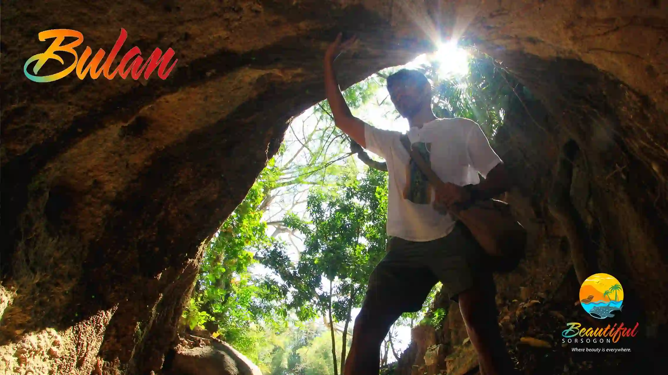
Bulusan is a Bikol word, meaning, a place where water flows. Indeed, water flows everywhere in Bulusan, cascading down from the forested slopes of Mt. Bulusan, its numerous springs and rivers swirling around the town, down to the man-made irrigation and sewerage canals, and out to the sea. Water flows and gurgles everywhere in Bulusan.
Its most famous landmarks are the still active Mt. Bulusan, looming large and serene 5,077 ft. above sea level, and two mountain lakes, Lake Bulusan, 2,084 ft. upon the slopes of the volcano, and the smaller one, Lake Agingay, a little higher up on the mountain slopes. The bigger Lake Bulusan, with a circumference of 2,006 meters, is reputed to be one of the most beautiful lakes in the world as attested to by often awe-struck foreign visitors. In fact, old time tourism blurbs quaintly pointed to it as the “Switzerland of the Orient”.
Old folks have woven a story around the volcano and the two lakes, who are supposed to be the tragic lovers, Bulusan and Agingay. This is why its annual fiesta every July 19 has been dubbed as the Agingay Festival.
The national government has declared the volcano and its surrounding lush forest, and the mountain lakes, as the Mt. Bulusan Natural Park in order to protect and preserve its natural ecosystem for all generations.
Geography
It is bordered by the towns of Barcelona in the north and, going counterclockwise, the towns of Casiguran, Juban, Irosin, and Santa Magdalena. The islets of San Bernardino, about 15 kilometres (9.3 mi) off the coast, fall under the jurisdiction of Bulusan. Bulusan is 55 kilometres (34 mi) from Sorsogon City and 636 kilometres (395 mi) from Manila.
Barangays
Bulusan is politically subdivided into 24 barangays. Each barangay consists of puroks and some have sitios.
There are 8 barangays located in the Poblacion area.
- Bagacay
- Central (Poblacion)
- Cogon
- Dancalan
- Dapdap (Poblacion)
- Lalud
- Looban (Poblacion)
- Mabuhay (Poblacion)
- Madlawon (Poblacion)
- Poctol (Poblacion)
- Porog
- Sabang (Poblacion)
- Salvacion
- San Antonio
- San Bernardo
- San Francisco (Kapangihan)
- San Isidro
- San Jose
- San Rafael (Likod)
- San Roque
- San Vicente (Buhang)
- Santa Barbara
- Sapngan (Poblacion)
- Tinampo
 Contact Bulan: lgubulan@gmail.com
The then large settlement of Bulan, which was a barrio of Gibalon, became a separate and independent parish in 1799, with Fr. Manuel Bernardo as its first parish administrator. The place was constituted into a pueblo civil in 1801 under the province of Albay.
It is widely believed that the name “Bulan” comes from the Bikol term for “moon”. However, in some Spanish maps, the name of the place is spelled “Builan”, with an i, but it is not known what it stood for. It must have just happened that in the course of time, the letter I was dropped and became simply “Bulan”, or the Moon Town, although it did not necessarily refer to our terrestrial satellite – the “moon”.
Bulan is one of the biggest towns in the province of Sorsogon. It is famous for its fish produce. Its waters is also known as the playing grounds of the frisky and playful dolphins. Sport fishers also regularly hie to the Bulan sea to watch for manta rays.
Bulan celebrates its patronal fiesta, in honor of its titular Our Lady of the Immaculate Conception every May 31 with a festival dubbed as the Padaraw Festival, the name referring to the powerful torchlight used by Bulan’s fishermen in drawing fish to their nets. The Padaraw Festival is a celebration of fishing. fishermen and bountiful fish harvest. On this day, fisherfolk thunder down the streets of Bulan dancing in celebration and thanksgiving.
Juban
This used to be a barrio of Casiguran until 1817 when it was organized as a separate parish. It was constituted as an independent pueblo civil in 1800.
It is believed that the name Juban comes from the Bikol word, “gujuban”, meaning, to groove or etch with a sharp instrument. Others, however, contend that the name really comes from “gujuban” which is a juice extracted from a certain tree which grew in the area. The juice was used by the natives for kindling. Thus, one goes to Juban to get one’s supply of the tree sap or juice used for starting cooking fire.
But Juban is also infamously known as a haven to numerous witches’ coven. But such witches’ stories are mostly apocryphal. They must have arisen from the fact that Juban of old was known for good hilots or herbolarios with their secret herbal concoctions and incantations which were magically curative. They were also sought after to exorcise persons possessed by evil spirits. In fact, they had such magical powers that they were considered aswangs or witches, not in a pejorative sense, but in respect and awe. They must have been descendants of our ancient tribal balyanas, babaylanes, asog, or shamans.
Lining the national highway passing through Juban town are still well-preserved turn-of-the- century colonial houses or bahay-na-bato. One also finds similar types of houses in the interiors of the town. It is the one town in the province with so many bahay-na-bato still standing and in use. Many Juban residents are also in possession of numerous kinds of artifacts that they unearth from their ricefields. These are the cultural heritage materials that local cultural advocacy groups are seeking to collect and preserve.
Juban celebrates its patronal fiesta every July 19 with what they call the Bagacawa Festival. This refers to the wide metal frying pan or cawa which was used as a kind of warning bell when pounded or hammered repeatedly to alert people during those intermittent pirate raids or during calamities. It also refers to the local churchbells when rang to alert people, which sounded, according to naughty local folks, almost like a frying pan being banged by the cook to signal that food is ready, or baga cawa. This is a celebration of thanksgiving.
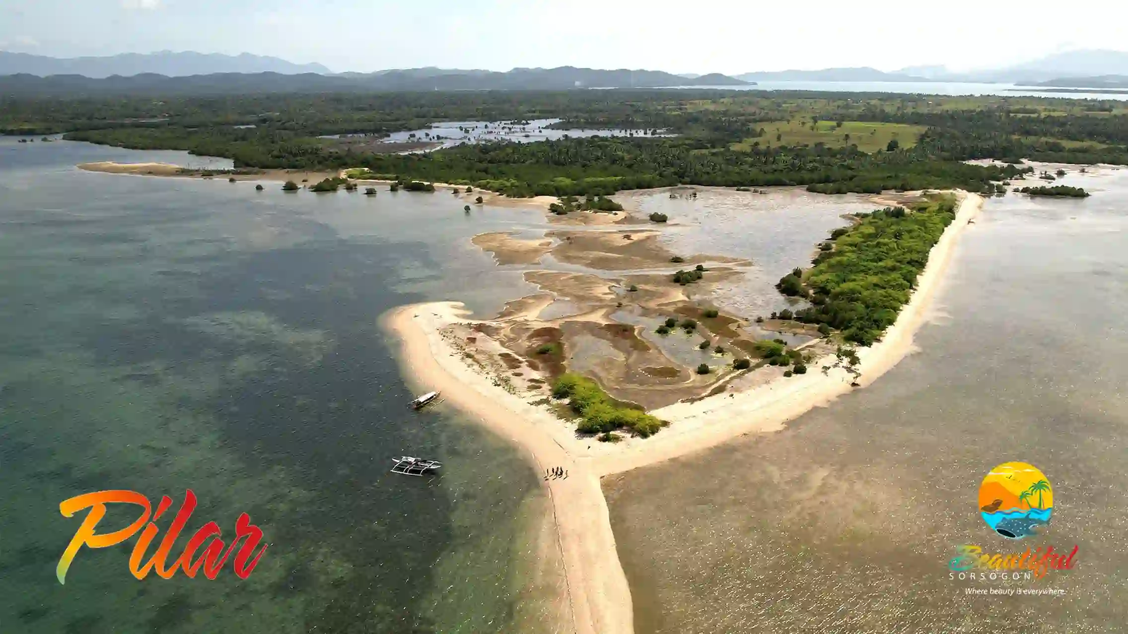
Pilar
It was on August 6, 1861 when the town of Pilar was created as a separate pueblo civil and, at the same time, an independent parish.
This came about as a result of a petition of the then residents of the village of Sto. Nino, which was then a visita of Donsol, together with the nearby visitas, to separate from their mother town of Cagsaua and become an independent pueblo civil. Thus, on this date, then Governor-General Lemery decreed the fusion of these adjoining visitas, which include Sto. Nino, Putiao, Sapa, Inang, Cadanlogan and Panlatuan, to become a new pueblo civil called “Pilar” after the newly-born infant of the king and queen of Spain.
It was in what is now the territory of Pilar where the Augustinian friars, Fray Alonso Jimenez and Fray Juan Orta, established one of the first Christian settlements in this part of Luzon. This was the Abucay- Catamlangan mission, which was established by the Augustinians in 1570, or immediately after establishing the Christian settlement of Gibalong, in what is now Magallanes town.
Pilar is reputed to be a shipbuilding town, with its menfolk expert in the building of ships or galleons. In fact, Panlatuan in Pilar is considered as one of the bigger shipbuilding sites in this part of Luzon. A fortress-like structure, complete with thick stone walls, a kind of huge kiln at the center, still remain at the site which used to be an astillero, or shipyard.
This is why, the annual fiesta of Pilar, in honor of its titular patron Nuestra Senora del Pilar, every October 12, has been dubbed the Parau Festival featuring colorful sailboats crafted by Pilar’s expert boatmen.
Travelers going to the island province of Masbate can take small ferry boats or motorized bancas, which regularly ply the Masbate route, at the fairly- busy Pilar seaport.
Barangays
Bulan is politically subdivided into 63 barangays. Each barangay consists of puroks and some have sitios.
- A. Bonifacio (Tinurilan)
- Abad Santos (Kambal)
- Aguinaldo (Lipata Dako)
- Antipolo
- Aquino (Imelda)
- Bical
- Beguin
- Bonga
- Butag
- Cadandanan
- Calomagon
- Calpi
- Cocok-Cabitan
- Daganas
- Danao
- Dolos
- E. Quirino (Pinangomhan)
- Fabrica
- G. Del Pilar (Tanga)
- Gate
- Inararan
- J. Gerona (Biton)
- J.P. Laurel (Pon-od)
- Jamorawon
- Libertad (Calle Putol)
- Lajong
- Magsaysay (Bongog)
- Managa-naga
- Marinab
- Nasuje
- Montecalvario
- N. Roque (Calayugan)
- Namo
- Obrero
- Osmeña (Lipata Saday)
- Otavi
- Padre Diaz
- Palale
- Quezon (Cabarawan)[5]
- R. Gerona (Butag)
- Recto
- Roxas (Busay)
- Sagrada
- San Francisco (Polot)
- San Isidro (Cabugaan)
- San Juan Bag-o
- San Juan Daan
- San Rafael (Togbongon)
- San Ramon
- San Vicente
- Santa Remedios
- Santa Teresita (Trece)
- Sigad
- Somagongsong
- Tarhan
- Taromata
- Zone 1 (Ilawod)
- Zone 2 (Sabang)
- Zone 3 (Central)
- Zone 4 (Central Business District)
- Zone 5 (Canipaan)
- Zone 6 (Baybay)
- Zone 7 (Iraya)
- Zone 8 (Loyo)
 Contact Barcelona: wework.barcelonaph@yahoo.com
The Spaniards seem to have had a special attachment to the places they
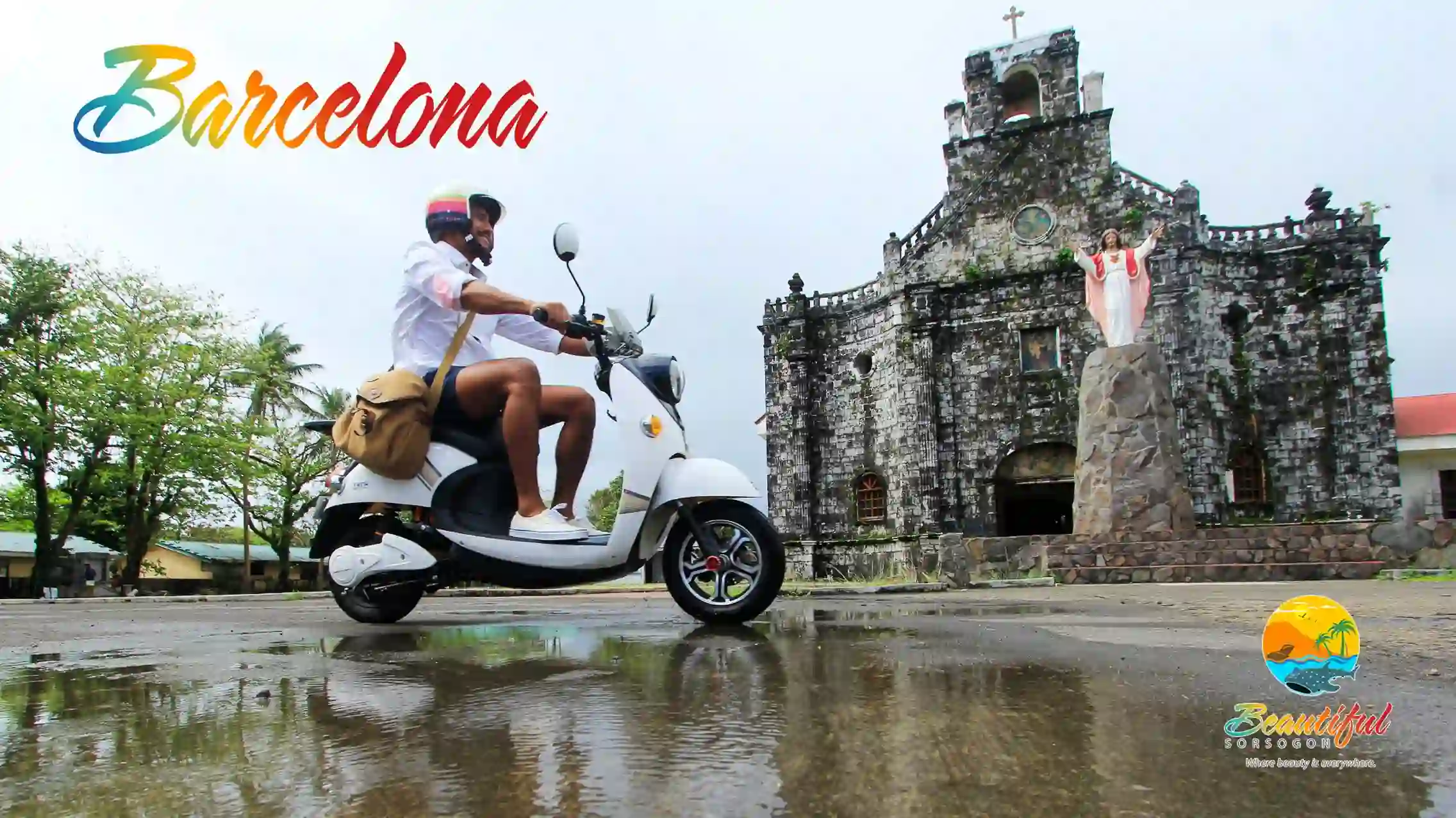
occupied in Sorsogon and the rest of Bicol, shown by the fact that they named some of these places after prominent Spanish places and personages. Call it colonialist nostalgia or homesickness, but one example of this is Barcelona, which was named after that famous Spanish tourist city of Barcelona. The story goes that a Spanish official noticed the resemblance of the panoramic view of Danlog to that of Barcelona of their Spanish homeland. Thus, they rechristened it Barcelona.
On November 15, 1865, because of persistent petitions from the residents of Danlog (original name of Barcelona, which was then just a visita of Gubat). claiming their village would grow and fare better if separated from Gubat, the Spanish authoritieis approved the creation of Barcelona as a new town, together with the visitas of Tagdon also of Gubat: and Layog and Macabari, of Bulusan. Don Juan Evasco was appointed as its first gobernadorcillo.
Barcelona became an independent parish in 1868, with St. Joseph as its titular or patron saint, whose feast day, which is also the town fiesta, is on May 19. Its first pastor was Fr. Mariano Garcia.
The stone church of Barcelona is one of the most well-preserved and oldest churches in the Bicol Region, with its original façade and thick stone walls still intact. It was constructed in 1870. In front of the church, just across the street, with the sea almost lapping at its doorsteps, are, to its left, the ruins of the old presidencia, or casa tribunal, or municipal hall, which also doubled as a kind of fortification and watchtower to watch out for pirates; and to its right, the stone schoolhouse. It is one example of a typical traditional Spanish colonial town plan, with the triangle of the house of God, the civilian government house, and the schoolhouse in place.
Irosin
When the place was organized as a visita of Bulusan in 1847, it was referred to as “Hin-ay”, derived from the native term for the way the abaca fibers are arranged on the loom for weaving. The word also refers to the way rivers weave their way downstream, like the tresses of a woman weaving and interlacing over each other as they flow effortlessly and gracefully over her shoulders.
The place later became known as San Miguel after the name of their chosen patron saint, St. Michael, the Archangel, when it became an independent parish in 1873, with Fr. Mariano Miranda as its first parish administrator. It became an independent pueblo civil in 1880 and renamed Irosin.
The name Irosin is said to be derived from the old Bikol word “iros”, meaning to cut off a part, or tear down. This refers to the fact that Irosin, which is surrounded by mountains, and is the only landlocked town in the province, is often witness to landslides or erosion of its mountainsides either because of river flows or earthquakes which trigger the sudden earth movements.
Volcanologists believe that trosin town actually sits upon a huge caldera, a cauldron-like depression created after the eruption of a volcano. According to this theory. Mt. Bulusan is actually not the volcano itself, but a mere fissure of a much bigger volcano, the crater of which, now forming a caldera, is the valley of Irosin, created when this huge volcano, whose base must be underneath the sea, erupted millions of years ago.
This explains why Irosin valley is so fertile that it has gained the reputation as the ricebowl and rice granary of the province. Which is also the reason why Irosin dubbed its annual festival the Paray Festival. every September 29. “Paray” is Bikol for rice. And rice. in its different culinary concoctions, particularly as karan-on (native rice snacks) is paraded proudly all over town during the Paray Festival.
Geography
Barangays
Barcelona is politically subdivided into 25 barangays. Each barangay consists of puroks and some have sitios.
In 1957, the name of barrio Paghabulan was changed to Peña Francia.
- Alegria
- Bagacay
- Bangate
- Bugtong
- Cagang
- Fabrica
- Jibong
- Lago
- Layog
- Luneta
- Macabari
- Mapapac
- Olandia
- Paghaluban
- Poblacion Central
- Poblacion Norte
- Poblacion Sur
- Putiao
 Contact Casiguran: casiguranmio@gmail.com
Established in the year 1600, Casiguran was the very first missionary parish of Sorsogon. It became the base of operations for the evangelization work started sometime in the 1570s in these parts by the Augustinian friars, Fray Alonso Jimenez and Fray Juan Orta. When the Franciscans took over in 1583, they also made the parish their base of operations covering the territories that later became the Province of Sorsogon.
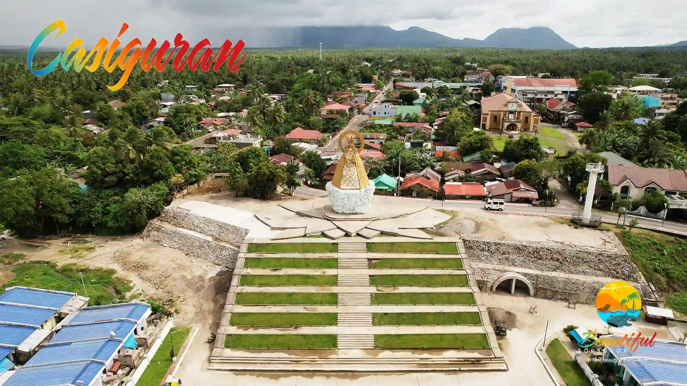
The name Casiguran is believed to come from the Bikol phrase casi gurang, meaning, mostly old or aged, pointing to the fact that it was the first parish and, therefore, the oldest, and thus, considered to be populated by senior or elderly inhabitants.
As the missionary center in this part of Bikol, its titular head or patron, up to the present day, is the Our Lady of the Most Holy Rosary, whose feast day is celebrated annually, October 7, as the Gugurang Festival.
Casiguran officially became a pueblo civil, or municipio, or town. sometime in the 1800s covering the territories of Bacon, Bulusan, Gubat and Sorsogon, which, later, also all became separate towns or municipios.
First Parish in Sorsogon
Casiguran is a town located on the coast of Sorsogon Bay. At the sitio of Binanuahan, barangay Boton, Casiguran was originally founded. It was later transferred to its present site.
The historical importance of this municipality is the fact that it was the first settlement established by the Spanish missionaries in the Province of Sorsogon and made the center of operations for Ibalon in the early period for the Christianization campaign in the southern areas of Bicolandia.
In his book, Estado Geografico Estatistico Historico Religiosos de las Islas Filipinas, Fray Felix Huertas, OFM, founder of Casiguran as the first Catholic mission settlement under the Franciscans, attests that Casiguran was the very first town in southern Ibalon (Bikol) organized in the Province of Albay and evangelized in the year 1600. But it was not until 1609 that it was made a parish, having Fray Antonio de San Francisco as its first pastor. This makes Casiguran the oldest parish in the Province of Sorsogon.
The first church in Casiguran was dedicated to Our Lady of Visitation and had its patronal fiesta on the 2nd of July in 1680, but the first Dominican Bishop, Most Rev. Fray Andres Gonzales, changed it to Our Lady of the Holy Rosary, which is the patroness of the parish up to this day. FR. ISIDORO DINO
Geography
Casiguran is located at the coast of Sorsogon Bay, at the south of Luzon island, making it a suburb of neighboring Sorsogon City. It is 17 kilometres (11 mi) from Sorsogon City and 598 kilometres (372 mi) from Manila.
Barangays
Casiguran is politically subdivided into 25 barangays. Each barangay consists of puroks and some have sitios.
 Contact Castilla: progresibonglgucastilla@gmail.com
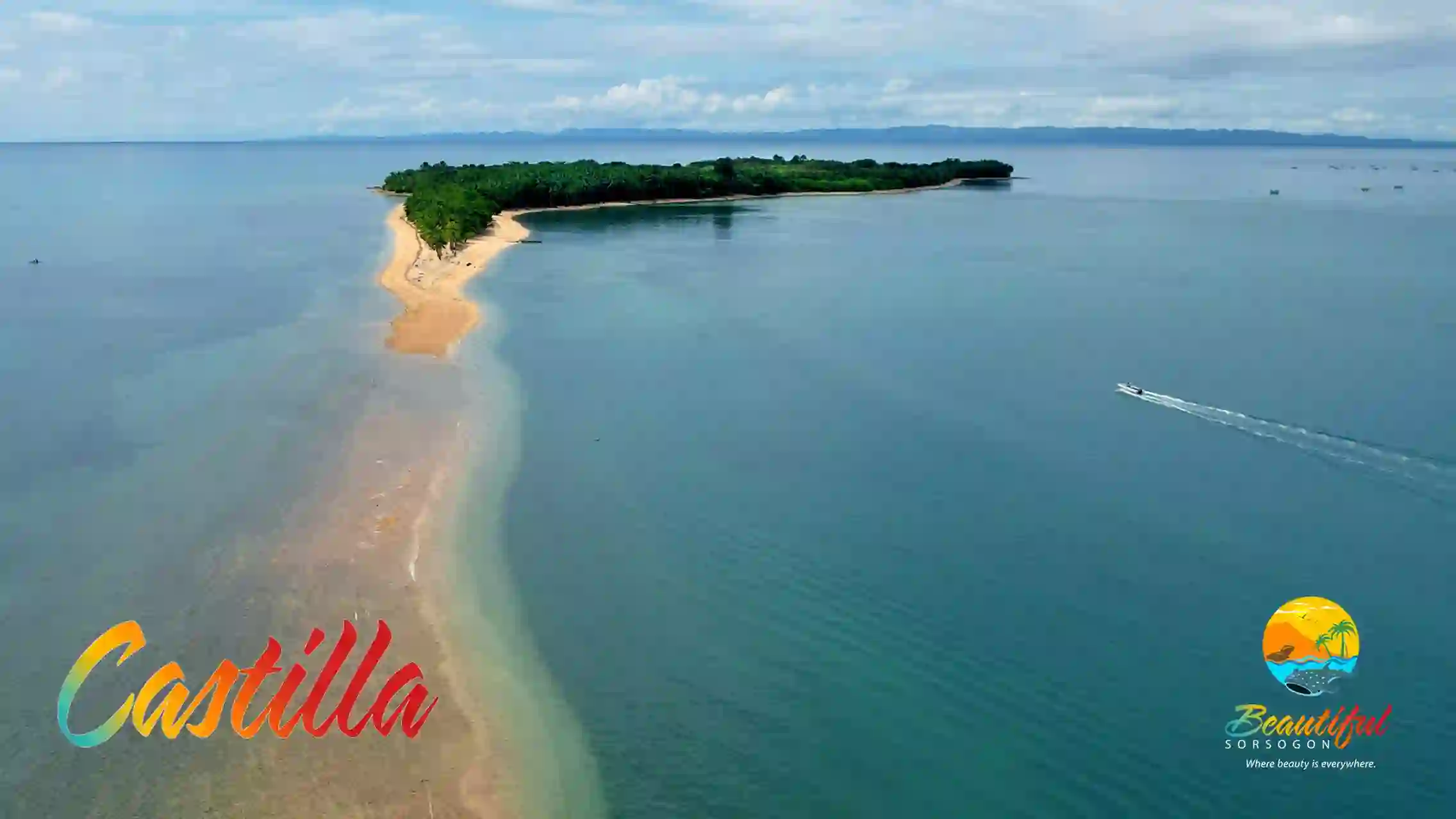
The place used to be known as Bolabog, a visita of Sorsogon, located along the coas of Sorsogon Bay. In 1827, it became a separate pueblo civil. Bolabog, meanwhile, has become a mere barangay of Sorsogon up to this day.
It became an independent parish on June 24, 1877, with its titular and patron, St. John, the Baptist.
Because of its rapid growth, the town’s residents petitioned the colonial authorities that their town site be transferred to the former ancient village of Ynarihan, a sitio nearer the coast of Sorsogon Bay which offered better opportunities for trading. The petition was approved by then Governor-General Norzagaray on October 3, 1859, while at the same time decreeing that its name be changed to “Castilla” after the name of the birthplace in Spain of Queen Isabela I.
Unfortunately, the supposed Castilla poblacion has been allowed by local government authorities to degenerate into a sleepy, neglected, ghost town of a place, overtaken by the more progressive barangay of Cumadcad, which is now, for all intents and purposes, the seat of the municipal government of Castilla. This unfortunate turn of events happened in the 1960s when the Pan Philippine Highway was being constructed and the highway sidelined Castilla poblacion and, instead, diverted to slice straight through the barangay of Cumadcad. Yet, because of its excellent seaport potentials, the Castilla poblacion, had the highway passed through it, could have been a busy interisland trading center.
At present, only passenger jeepneys regularly ply the route going into the poblacion, which a traveler takes at what local call, “Crossing”, or the highway junction that winds its way into the sleepy supposed to be town center.
Geography
Barangays
Castilla is divided into 34 barangays. Each barangay consists of puroks and some have sitios.
- Amomonting
- Bagalayag
- Bagong Sirang
- Bonga
- Buenavista
- Burabod
- Caburacan
- Canjela
- Cogon
- Cumadcad
- Dangcalan
- Dinapa
- La Union
- Libtong
- Loreto
- Macalaya
- Maracabac
- Mayon
- Milagrosa
- Miluya
- Maypangi
- Monte Carmelo
- Oras
- Pandan
- Poblacion
- Quirapi
- Saclayan
- Salvacion
- San Isidro
- San Rafael
- San Roque
- San Vicente
- Sogoy
- Tomalaytay
 Contact Donsol: donsollocalgovtph@gmail.com
This was a mere barrio of Quipia (now Jovellar, in Albay province) until 1668 when Donsol became an independent parish. Donsol became a pueblo civil, or town, in 1800.
The present townsite of Donsol used to be known as the ancient village or sitio of Barra, which is located near the coast. By virtue of a petition by the Donsol townsfolk, who were then situated in the interior, which is now known as Banuang Gurang (old town), seeking the town’s transfer to sitio Barra, because it would be, according to them, economically beneficial, the town was transferred to its present site on July 11, 1831. The move indeed proved to be most beneficial, with the ready availability of trading, transportation and communications in the new site, that Donsol so outstripped its former mother town Quipia that this became its mere visita until 1877 when Quipia, too, became a separate town under Albay, and renamed Jovellar.
Donsol got its name from “donsolan”. Bikol for anvil – that heavy metal block used by blacksmiths to fashion various metal implements, such as, machetes, knives, scissors, etc. According to ancient lore, Donsol was then inhabited by expert blacksmiths, which is why when one was looking for some place where one could get a machete or knife, one was invariably directed to go to the donsolan. Or go to Donsol.
Perhaps by way of confirmation of this fact, the National Museum discovered and unearthed in 1996 in barangay Dancalan the archeological remains of a metalworks factory together with an astillero or shipyard.
But Donsol is now famous worldwide, no longer for its metalworks, but for those awesome, but gentle, creatures known as Butandings, or whalesharks, that converge in large numbers at the mouth of the Donsol River during certain months of the year. With sizes ranging from 15 to 40 ft. in length, this pod of huge creatures, considered as the biggest fishes in the world, start swimming in starting October of each year, peaking during the months of February, March, April and May, when tourists, curiosity-seekers and scientists alike, descend upon Donsol eager to witness this phenomenon and interact or swim with the gentle and harmless creatures. Donsol celebrates this arrival of the Butandings each year and welcome them with their Butanding Arribada Festival during the month of March.
Geography
Barangays
Donsol is politically subdivided into 51 barangays. Each barangay consists of puroks and some have sitios.
- Alin
- Awaii (Poblacion)
- Banban
- Bandi
- Banuang Gurang
- Baras
- Bayawas
- Bororan Barangay 1 (Poblacion)
- Cabugao
- Central Barangay 2 (Poblacion)
- Cristo
- Dancalan
- De Vera
- Gimagaan
- Girawan
- Gogon
- Gura
- Juan Adre
- JR Cawaling
- Mabini
- Malapoc
- Malinao
- Market Site Barangay 3 (Poblacion)
- New Maguisa
- Ogod (Crossing)
- Old Maguisa
- Orange
- Pangpang
- Parina
- Pawala
- Pinamanaan
- Poso Pob. (Barangay 5)
- Punta Waling-Waling (Poblacion)
- Rawis (Poblacion Brgy)
- San Antonio
- San Isidro
- San Jose
- San Rafael
- San Ramon
- San Vicente
- Santa Cruz
- Sevilla
- Sibago
- Suguian
- Tagbac
- Tinanogan
- Tongdol
- Tres Marias (Poblacion Brgy)
- Tuba
- Tupas
- Vinisitahan
- Lourdes
 Contact Gubat: gubatsorsogon.lgu@gmail.com
On June 13, 1764, Gubat, which was until then, a barrio of Bulusan, was declared by the Spanish government a new pueblo civil or town, under the province of Albay. It became an independent parish also on the same day, June 13, but in the year 1771, with the Franciscan missionary, Fr. Geronimo Cabello, as its first parish administrator.
Gubat is said to have been founded by a certain Pedro Manuel Manook, one of the native allies of Legaspi in Bohol. Manook is said to be the son of Visayan chieftain Pagbuaya who, in turn, is the son of Catunao, known to most of us as Rajah Sikatuna, famous for his blood compact with Legaspi. Manook, who came with Legaspi’s troops to this part of Bikol settled on the shores of Gubat. Thus, the name of the main street of Gubat, to this day, is called Manook Street in honor of Don Pedro Manuel Manook who is reputed to be a brave warrior who, while staying in Gubat, converted to Christianity.
Gubat got its name from the old Bikol word, “gubat”, meaning, “to raid”. Because of its location along the coast, Gubat was one of the most frequently raided places by the then marauding pirates. Thus, the name, which is often mistaken to refer to a forest.
Forests are not what one will see or marvel at in Gubat town, but its wide, white sandy beaches. Gubat is famous for its Rizal Beach Resort in barangay Rizal.
Gubat celebrates its patronal fiesta, in honor of St. Anthony of Padua, on June 13, each year, with its Ginubat Festival featuring street dancers prancing down the streets of the town.
Geography
Gubat is in the south-eastern part of Luzon Island, along the coast of the Pacific Ocean on the Bicol Peninsula. It is the third largest town in the province of Sorsogon. It is divided into 2 districts: the North District and South District.
Barangays
Gubat is politically subdivided into 42 barangays. Each barangay consists of puroks and some have sitios.
Barangays with (Poblacion) indicate that barangay is part of the town proper or poblacion.
- Ariman
- Bagacay
- Balud Del Norte (Poblacion)
- Balud Del Sur (Poblacion)
- Benguet
- Bentuco
- Beriran
- Buenavista
- Bulacao
- Cabigaan
- Cabiguhan
- Carriedo
- Casili
- Cogon
- Cota Na Daco (Poblacion)
- Dita (Estillero)
- Jupi (Estillero)
- Lapinig (Estillero)
- Luna-Candol (Poblacion)
- Manapao
- Manook (Poblacion)
- Naagtan
- Nato
- Nazareno
- Ogao
- Paco
- Panganiban (Poblacion)
- Paradijon (Poblacion)
- Patag
- Payawin
- Pinontingan (Poblacion)
- Rizal
- San Ignacio
- Sangat
- Santa Ana
- Tabi
- Tagaytay
- Tigkiw
- Tiris
- Togawe
- Union
- Villareal
 Contact Irosin: municipalityofirosin@gmail.com
When the place was organized as a visita of Bulusan in 1847, it was referred to as “Hin-ay”, derived from the native term for the way the abaca fibers are arranged on the loom for weaving. The word also refers to the way rivers weave their way downstream, like the tresses of a woman weaving and interlacing over each other as they flow effortlessly and gracefully over her shoulders.
The place later became known as San Miguel after the name of their chosen patron saint, St. Michael, the Archangel, when it became an independent parish in 1873, with Fr. Mariano Miranda as its first parish administrator. It became an independent pueblo civil in 1880 and renamed Irosin.
The name Irosin is said to be derived from the old Bikol word “iros”, meaning to cut off a part, or tear down. This refers to the fact that Irosin, which is surrounded by mountains, and is the only landlocked town in the province, is often witness to landslides or erosion of its mountainsides either because of river flows or earthquakes which trigger the sudden earth movements.
Volcanologists believe that trosin town actually sits upon a huge caldera, a cauldron-like depression created after the eruption of a volcano. According to this theory. Mt. Bulusan is actually not the volcano itself, but a mere fissure of a much bigger volcano, the crater of which, now forming a caldera, is the valley of Irosin, created when this huge volcano, whose base must be underneath the sea, erupted millions of years ago.
This explains why Irosin valley is so fertile that it has gained the reputation as the ricebowl and rice granary of the province. Which is also the reason why Irosin dubbed its annual festival the Paray Festival. every September 29. “Paray” is Bikol for rice. And rice. in its different culinary concoctions, particularly as karan-on (native rice snacks) is paraded proudly all over town during the Paray Festival.
Geography
Irosin is the only landlocked municipality in the province. It is 42 kilometres (26 mi) from Sorsogon City and 623 kilometres (387 mi) from Manila.
Barangays
Irosin is politically subdivided into 28 barangays. Each barangay consists of puroks and some have sitios.
- Bagsangan
- Bacolod (Poblacion)
- Batang
- Bolos
- Buenavista
- Bulawan
- Carriedo
- Casini
- Cawayan
- Cogon
- Gabao
- Gulang-Gulang
- Gumapia
- Santo Domingo (Lamboon)
- Liang
- Macawayan
- Mapaso
- Monbon
- Patag
- Salvacion
- San Agustin (Poblacion)
- San Isidro (Palogtok)
- San Juan (Poblacion)
- San Julian (Poblacion)
- San Pedro (Poblacion)
- Tabon-Tabon
- Tinampo
- Tongdol
 Contact Juban: lgujuban123@gmail.com
This used to be a barrio of Casiguran until 1817 when it was organized as a separate parish. It was constituted as an independent pueblo civil in 1800.
It is believed that the name Juban comes from the Bikol word, “gujuban”, meaning, to groove or etch with a sharp instrument. Others, however, contend that the name really comes from “gujuban” which is a juice extracted from a certain tree which grew in the area. The juice was used by the natives for kindling. Thus, one goes to Juban to get one’s supply of the tree sap or juice used for starting cooking fire.
But Juban is also infamously known as a haven to numerous witches’ coven. But such witches’ stories are mostly apocryphal. They must have arisen from the fact that Juban of old was known for good hilots or herbolarios with their secret herbal concoctions and incantations which were magically curative. They were also sought after to exorcise persons possessed by evil spirits. In fact, they had such magical powers that they were considered aswangs or witches, not in a pejorative sense, but in respect and awe. They must have been descendants of our ancient tribal balyanas, babaylanes, asog, or shamans.
Lining the national highway passing through Juban town are still well-preserved turn-of-the- century colonial houses or bahay-na-bato. One also finds similar types of houses in the interiors of the town. It is the one town in the province with so many bahay-na-bato still standing and in use. Many Juban residents are also in possession of numerous kinds of artifacts that they unearth from their ricefields. These are the cultural heritage materials that local cultural advocacy groups are seeking to collect and preserve.
Juban celebrates its patronal fiesta every July 19 with what they call the Bagacawa Festival. This refers to the wide metal frying pan or cawa which was used as a kind of warning bell when pounded or hammered repeatedly to alert people during those intermittent pirate raids or during calamities. It also refers to the local churchbells when rang to alert people, which sounded, according to naughty local folks, almost like a frying pan being banged by the cook to signal that food is ready, or baga cawa. This is a celebration of thanksgiving.
Geography
Barangays
Juban is politically subdivided into 25 barangays. Each barangay consists of puroks and some have sitios.
- Añog
- Aroroy
- Bacolod
- Binanuahan
- Biriran
- Buraburan
- Calateo
- Calmayon
- Caruhayon
- Catanagan
- Catanusan
- Cogon
- Embarcadero
- Guruyan
- Lajong
- Maalo
- North Poblacion
- South Poblacion
 Contact Magallanes: contact@magallanessorsogon.gov.ph
This was the ancient village of Yguey, which later became known to the Spaniards as Encomienda de Yguey, with two visitas – Parina and Caditaan. The present townsite of Magallanes is the then visita of Parina.
Upon the initiative of Spanish abaca trader Don Manuel de Castro, together with a petition from the inhabitants, of the formerly abandoned villages of Parina and Caditaan, the Spanish colonial government approved the establishment of Magallanes as a new town on April 30, 1859, naming it in honor of the circumnavigator of the world, Fernando de Magallanes. De Castro, who also operated an astillero or shipyard in the place. became its first gobernadorcillo.
Magallanes became an independent parish on December 11, 1863. It is in Magallanes where Gibalong (now sitio San Isidro) is located, at the mouth of the Ginangra River. reputed to be the place where the first Christian mass in Luzon was celebrated. The place also holds the distinction of being the first Christian settlement in this part of the country. In fact, the name Ibalon, which is also used to identify the whole Bicol Region, comes from the name of the place Gibalong. In many old Spanish maps the name Tierra de Gibalong was used to identify the place, which, for a time became the seat of governance in this part of Luzon.
A historico-religious shrine is now in place on the site, a joint project of the Sorsogon provincial government and the Kasanggayahan Foundation, Inc. It is the site of the annual pilgrimage in commemoration of the first mass in Luzon Island, every October, during the Kasanggayahan Festival.
It is also in Magallanes where Bagatao Island is located, just at the mouth of Sorsogon Bay. Bagatao Island is considered as one of the most important and biggest shipyards at the time, where some of the biggest and most magnificent Spanish galleons were constructed. It was then known as the Real Astillero de Bagatao.
Geography
Barangays
Magallanes is politically subdivided into 34 barangays. Each barangay consists of puroks and some have sitios.

- Aguada Norte
- Aguada Sur
- Anibong
- Bacalon
- Bacolod
- Banacud
- Biga
- Behia
- Binisitahan del Norte
- Binisitahan del Sur
- Biton
- Bulala
- Busay
- Caditaan
- Cagbolo
- Cagtalaba
- Cawit Extension
- Cawit Proper
- Ginangra
- Hubo
- Incarizan
- Lapinig
- Magsaysay
- Malbog
- Pantalan
- Pawik
- Pili
- Poblacion
- Salvacion
- Santa Elena
- Siuton
- Tagas
- Tulatula Norte
- Tulatula Sur
 Contact Matnog: matnogsorsogon.lgu@gmail.com
This became an independent parish, separate from Bulusan, in 1863. Before this, in 1800, it became an independent pueblo civil under the province of Albay.
From its original site, now simply known to residents as Banuangdaan (old town), the poblacion was transferred to its present site in 1898, the southernmost tip of Luzon, where it now has a large ferry terminal with regular daily ferry trips to Samar. With its roll-on, roll-off (RORO) ferry terminal facilities, Matnog is a busy port town, loading and moving people, cargo and vehicles to the Visayas. and disgorging people, cargo and vehicles into Luzon, it is considered as the “Gateway to the South” of the Philippines.
The name Matnog is said to be a corruption of the Bikol word “matonog”, meaning a noisy. deafening sound. This refers to the roaring, howling. almost moaning sound created by the numerous whirlpools punctuating the seas surrounding Matnog. Residents call these “lambiyong”. Expert Matnog boatmen make sport of these series of lambiyongs by guiding their boats and gliding gracefully through them like a kind of extreme slalom ride. The bigger or wider whirlpools can actually swallow a boat and its crew and pull it into the deep, if the boatmen are not careful.
The Matnog waters is known as rich fishing ground for deepsea or sport fishing, where divers and tourists can also enjoy the sights and pleasures offered by its exotic little islands dotting the sea. There is Tikling Island, which is just a few oar-strokes away from the ferry terminal, with fine, white sand beach ringing the island; the Calintaan Island with its subterranean giant bat caves: Subic with its sexy pink sand; and numerous other tiny islands just waiting to be explored.
Matnog celebrates its town fiesta, May 16, in honor of the Holy Infant Jesus.
Geography
Barangays
Matnog is politically subdivided into 40 barangays. Each barangay consists of puroks and some have sitios.
- Balocawe
- Banogao
- Banuang-daan
- Bariis
- Bolo
- Bon-Ot Dako (Big)
- Bon-Ot Saday (Small)
- Cabagahan
- Calayuan
- Calintaan
- Caloocan (Poblacion)
- Calpi
- Camachiles (Poblacion)
- Camcaman (Poblacion)
- Coron-coron
- Culasi
- Gadgaron
- Genablan Occidental
- Genablan Oriental
- Hid-hid
- Laboy
- Lajong
- Mambajog
- Manjumlad
- Manurabi
- Naburacan
- Paghuliran
- Pange
- Pawa
- Poropandan
- Santa Isabel
- Sinalmacan
- Sinang-Atan
- Sinebaran
- Sisigon
- Sua
- Sulangan
- Tablac (Poblacion)
- Tabunan (Poblacion)
- Tugas
 Contact Pilar: pilarsor.mayor@gmail.com
It was on August 6, 1861 when the town of Pilar was created as a separate pueblo civil and, at the same time, an independent parish.
This came about as a result of a petition of the then residents of the village of Sto. Nino, which was then a visita of Donsol, together with the nearby visitas, to separate from their mother town of Cagsaua and become an independent pueblo civil. Thus, on this date, then Governor-General Lemery decreed the fusion of these adjoining visitas, which include Sto. Nino, Putiao, Sapa, Inang, Cadanlogan and Panlatuan, to become a new pueblo civil called “Pilar” after the newly-born infant of the king and queen of Spain.
It was in what is now the territory of Pilar where the Augustinian friars, Fray Alonso Jimenez and Fray Juan Orta, established one of the first Christian settlements in this part of Luzon. This was the Abucay- Catamlangan mission, which was established by the Augustinians in 1570, or immediately after establishing the Christian settlement of Gibalong, in what is now Magallanes town.
Pilar is reputed to be a shipbuilding town, with its menfolk expert in the building of ships or galleons. In fact, Panlatuan in Pilar is considered as one of the bigger shipbuilding sites in this part of Luzon. A fortress-like structure, complete with thick stone walls, a kind of huge kiln at the center, still remain at the site which used to be an astillero, or shipyard.
This is why, the annual fiesta of Pilar, in honor of its titular patron Nuestra Senora del Pilar, every October 12, has been dubbed the Parau Festival featuring colorful sailboats crafted by Pilar’s expert boatmen.
Travelers going to the island province of Masbate can take small ferry boats or motorized bancas, which regularly ply the Masbate route, at the fairly- busy Pilar seaport.
Geography
Barangays
Pilar is politically subdivided into 49 barangays. Each barangay consists of puroks and some have sitios.
In 1957 the sitios of Naspi and Calaguitan were separated from the barrio of Putiao and converted into the barrio of Naspi.
- Abas
- Abucay
- Bantayan
- Banuyo (Poblacion)
- Bayasong
- Bayawas
- Binanuahan (Poblacion)
- Cabiguan
- Cagdongon
- Calongay
- Calpi
- Catamlangan
- Comapo-capo
- Danlog
- Dao (Poblacion)
- Dapdap
- Del Rosario (Bual)
- Esmerada
- Esperanza
- Guiron
- Ginablan
- Inang
- Inapugan
- Lubiano
- Leona
- Lipason
- Lourdes
- Lungib
- Lumbang
- Mabanate
- Malbog
- Marifosque (Poblacion)
- Mercedes
- Migabod
- Naspi
- Palanas
- Pangpang
- Pinagsalog
- Pineda
- Poctol
- Pudo
- Putiao
- Sacnangan
- Salvacion
- San Antonio (Millabas)
- San Antonio (Sapa)
- San Jose
- San Rafael
- Santa Fe
 Contact Prieto Diaz: lce.prietodiaz@yahoo.com
After many years of appealing to become an independent parish and pueblo civil from its mother town of Bacon, through petitions since 1833, it finally got the nod from the Spanish authorities and became an independent parish in 1881, with Fr. Mariano Banez as its first pastor.
Originally identified as Montupar Point, this jut of land that reaches out into the turbulent waters of the San Bernardino Strait became an independent municipality on January 1, 1904 and renamed after the two priests who were lumped together into the group now known as the 15 Bicol Martyrs (Quince Martires) who were ordered by Spanish authorities executed for rebellion Fr. Gabriel Prieto and Fr. Severino Diaz.
Because of this, it is the only town in the province with a hyphenated name. It is also the only town in Sorsogon that was constituted as such after Sorsogon itself became an independent province.
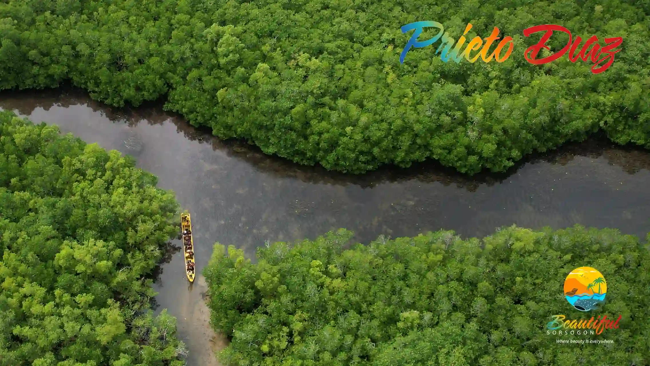
Prieto-Diaz is the recipient of the 1998 Best Community-Based Coastal Resources Management Program awarded by the United States Agency for International Development (USAID), making it a model site for its natural mangrove forest, mangrove plantations and nursery, wide stretches of seagrass and mud flats, and protected coral reefs. It also features a breath-taking canopy walk over its mangrove forest.
Prieto-Diaz celebrates its patronal fiesta in honor of St. Lawrence, August 9-10, dubbed as the Kaligay Festival a festival of seashells found in abundance along the shores of the town, particularly the tiny pearly white kaligay shells that are strung together and fashioned into different ornamental or decorative items, which has become a thriving cottage industry of the small town.
Geography
Prieto-Diaz is 387 km (241 mi) southeast of Manila, 150 km(31m) east-southeast of Legazpi City, the regional center and 20 km (12.4 mi) north-north-east of Sorsogon City, the provincial capital. North of Prieto-Diaz across Albay Gulf is Rapu-Rapu, Albay, on the west is Bacon District of Sorsogon City and on the south is Gubat, Sorsogon while Pacific Ocean is on the east. It is also the easternmost point on the Island of Luzon.
Barangays
Prieto-Diaz is politically subdivided into 23 barangays. Each barangay consists of puroks and some have sitios.
In 1954, sitio Carayat was converted into a barrio.
- Brillante (Poblacion)
- Bulawan
- Calao
- Carayat
- Diamante
- Gogon
- Lupi
- Manlabong
- Maningcay De Oro
- Perlas
- Quidolog
- Rizal
- San Antonio
- San Fernando
- San Isidro
- San Juan
- San Rafael
- San Ramon
- Santa Lourdes
- Santo Domingo
- Talisayan
- Tupaz
- Ulag
 Contact Sta. Magdalena: lgu.smmo@gmail.com
Busaingan is the ancient name of the place – an old Bikol term, meaning, where the waves break. The picturesque Bikol word connotes loud crashing sounds as huge waves break and smash against the treacherous rock wall along the shore.
Busaingan was first organized as a visita under Bulusan. But, when Matnog became a pueblo civil in 1800, Busaingan was ceded to it. It later became an independent parish in 1890 with St. Francis of Assisi as its original titular. In November 1894, it became a pueblo civil, first under Albay, and, a few days later, under the newly-separated, independent province of Sorsogon.
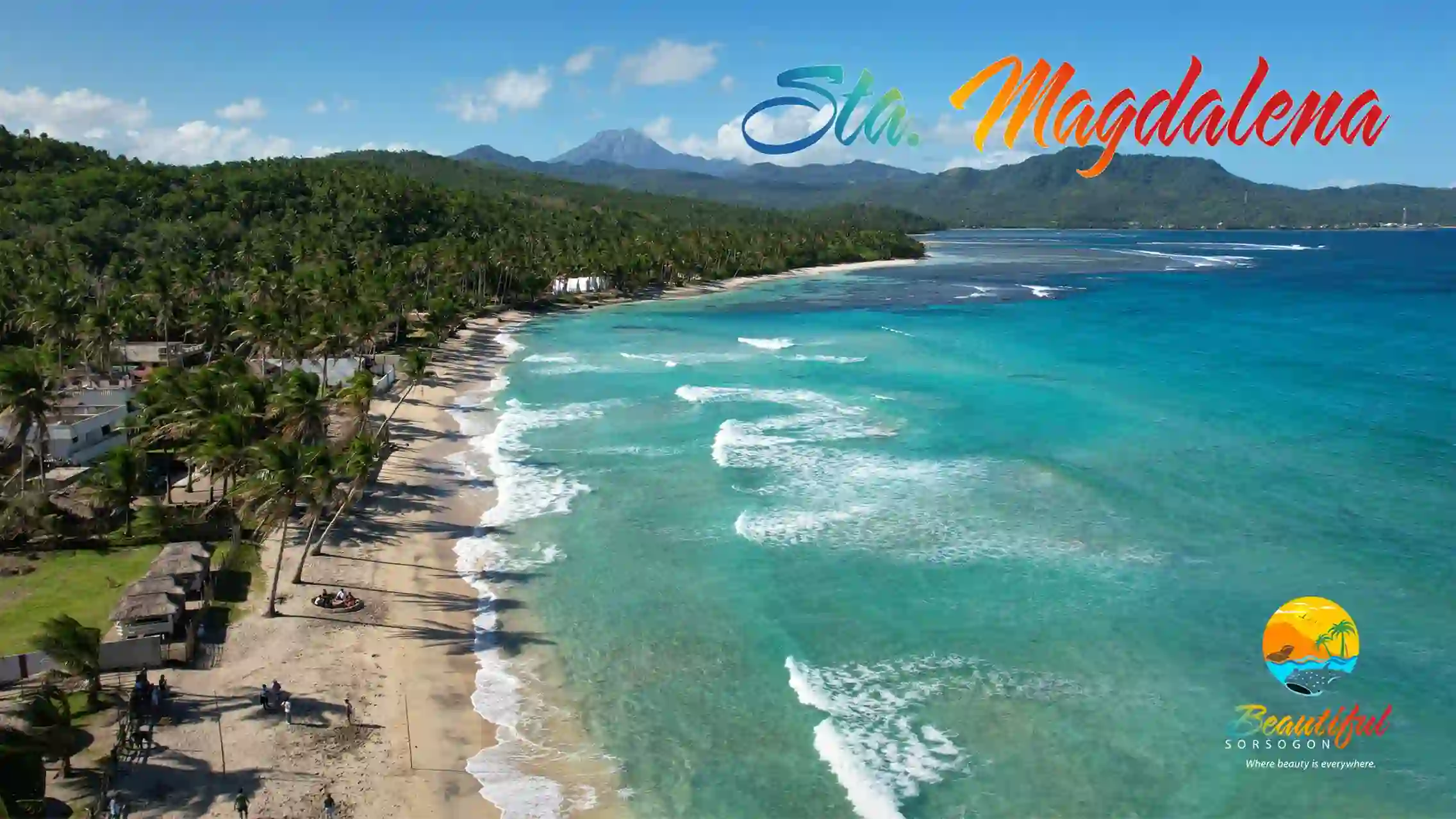
Sometime in the early 1900s, the townsfolk decided to transfer their poblacion to its present site and have St. Mary Magdalene as their titular head, whose feast day is July 22. They also decided to change the name of their town from Busaingan to Sta. Magdalena.
Although Sta. Magdalena is the smallest town in the province of Sorsogon, with a land area of only 3.970 hectares, it offers some of the best white sand beach resorts in the Bicol Region.
Geography
It is bounded by Bulusan, Matnog and Irosin. It is the smallest municipality in the province, both in population and area. The territorial jurisdiction of the municipality comprises some 4706.443 hectares of land mass and areas of sea territory.
The local government unit is politically subdivided into 14 barangays, dispersed geographically in the lowlands of Poblacion (4 barangays) and upland (10 barangays). It has 13 coastal barangays and 1 inland barangay (La Ezperansa).
Barangays
Santa Magdalena is politically subdivided into 14 barangays. Each barangay consists of puroks and some have sitios.
- San Francisco (Barangay I Poblacion)
- Mother of Perpetual (Barangay II Poblacion)
- Del Rosario (Barangay III Poblacion)
- Santo Niño (Barangay IV Poblacion)
- La Esperanza (Manangkas)
- Peñafrancia (Uson)
- Salvacion (Taverna)
- San Antonio (Kaburihan)
- San Bartolome (Talaongan)
- San Eugenio (Alig-igan)
- San Isidro (Bilaoyon)
- San Rafael (Bil-og)
- San Roque (Alambre)
- San Sebastian (Bigo)
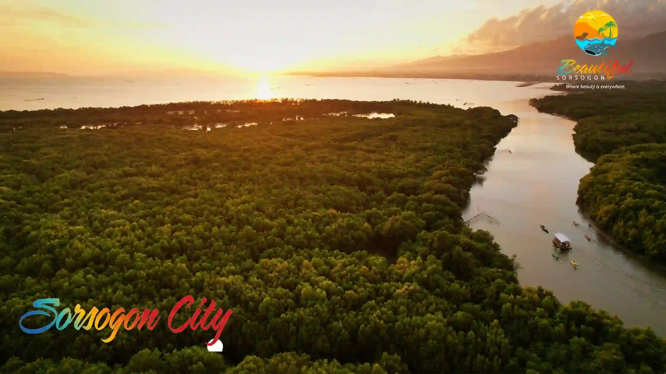 Contact Sorsogon City: mayor.esterhamor.lgusorcity@gmail.com
Growth in the number of converts to Christianity eventually led to the separation of Sorsogon from Bacon in 1628, with Domanaog as its visita.
The original site of the new parish was a small fishing village along a small river now known as sitio Pocdol, in barangay Capuy, to which several families from Bacon, fearful of the constant pirate raids, moved and settled. The site is still referred to today by barangay residents as “binanuahan”, or the old town, where its physical remains can still be seen.
It was from this small river running through the village, now known as the Sorsogon River, that Sorsogon got its name. According to this old and popular folk tale about how Sorsogon got its name, a group of Spaniards, as the story goes, got lost somewhere around the Bay. Fortunately, they chanced upon a native fisherman whom they asked for the name of the place. The native, thinking that the strangers were asking for directions, simply said, “Sosogon”, while pointing at the river going upstream. He was directing the strangers to the village beyond. The Spaniards thought that was the name of the place. And the name stuck – from sogsogon, solsogon, or sosogon, to the present day “Sorsogon”.
Sometime in 1680, a catastrophe (it is not clear if it was natural or man-made, such as a pirate raid) razed the whole village to the ground, including the church and all the images of saints within. From the ashes, survivors discovered the images of St. Peter and St. Paul still miraculously intact. Thus, they became the patron saints of the town, which transferred to its present site during the same year. The titular or patronal fiesta is celebrated every June 29. It is also the city’s Pili Festival, in celebration of the Pili tree, dubbed as the “Majestic Tree of Sorsogon” because of its many uses – as food, fuel, shelter, including medicinal, industrial, and ornamental.
Sorsogon became a distinct political unit, or pueblo civil in 1764 under the Province of Albay. Today, as a component city, by virtue of Republic Act No. 8806, ratified on December 16, 2000, it is, as before, when it was still a municipality, still the capital of the Province of Sorsogon. Its foundation anniversary is celebrated every June 30 of each year.
BACON
Oldest Pueblo Civil of Sorsogon
On the year 1609, The Franciscans founded the settlement of Bacon, which later became a visita or barrio, and in 1617, it was separated from Casiguran to become an independent parish, which included Sta. Florentina (now Rapu-Rapu), and Montupar (now Prieto-Diaz).
Bacon’s patroness was Our Lady of the Annunciation, until Fray Gregorio Sta. Ana replaced it with Sta. Rita de Casia. In 1853, however, Fray Remigio de Vera returned the Our Lady of the Annunciation, as patroness of the parish, up to the present time.
Bacon is the oldest municipality (pueblo civil) of the province. It was founded in 1754. It is also the nearest town to the capital town of Sorsogon, with a distance of only nine kilometers. The road connecting it is the oldest in the province.
The Municipality of Bacon (now Bacon District, City of Sorsogon), as established by the Spanish government then, included under its jurisdiction the barrios of Sta. Florentina, Batan and Cagraray Islands.
When Sorsogon became an independent province from Albay, Bacon lost to Albay, Rapu-Rapu, Batan and Cagraray Islands. Also, the barrios of Suwa and Cabit were lost to the Municipality of Manito, also in Albay.
Rapu-Rapu became a municipality of Albay in 1901, while Prieto-Diaz was separated from Bacon in 1904, to become an independent municipality.
With the separation of Sorsogon from Albay, the boundaries separating them were moved from Balabagon to Suwa.
The Sorsogon-Bacon Bridge. Bacon was an important port during the Spanish period until the opening of the Sorsogon-Albay road in 1924. Government officials, businessmen and travellers from Manila used to come to Legaspi by train, and from Legaspi to Bacon, by the launch, San Antonio, and from Bacon to Sorsogon, by bus.
Due to the importance of the port in business, and the road, in transporting goods from Bacon to Sorsogon, Governor Penaranda of Albay issued a decree in 1814 ordering the construction of Gabao Bridge, to be finished in forty-five days by polistas. One-half of the bridge, on the Bacon side, was constructed by polistas from Bacon, and the other half, on the Sorsogon side, was constructed by polistas from Sorsogon,. This bridge is located at the boundary of Bacon and Sorsogon (Unfortunately, this bridge to the widening of the concrete roadway going into Bacon, no longer there, having given way which is now a mere district of Sorsogon City – ed.). FR. ISIDORO DINO
Geography
Sorsogon City covers a land area of 31,292 hectares (120.82 sq mi). It is at the southernmost tip of the Bicol Peninsula and of Luzon Island. The city is bounded by Castilla in the west, Manito in the northwest, Albay Gulf in the north, Prieto Diaz in the east, Gubat in the southeast, Casiguran in the southwest, and Sorsogon Bay in the south. Sorsogon is characterized by an irregular topography; mountain ranges on the north-west, sloping uplands on the central part of the city, plain areas southwestern and central north and southeast portion, and marshlands on the southeast deltas. It is also surrounded by water, with Sorsogon Bay to the west Albay Gulf to the northeast, and Philippine Sea in the east.
Sorsogon City is 581 kilometres (361 mi) southeast of Manila and 54 kilometres (34 mi) south of Legazpi City. The 2015 Census puts the city’s population at 168,110 with an annual growth rate of 0.84%. Sorsogon City ranked as the 3rd largest city in terms of population in the Bicol region. The only city in the province of Sorsogon, Sorsogon City is the largest in terms of land area in the Bicol region.
The Pan-Philippine Highway which runs from northwest to southeast through the city, connects Sorsogon City to the municipalities of Castilla, Pilar, in the northwest towards Daraga, Legazpi City, Naga City and the rest of Luzon. It also connects to the municipalities of Gubat, Casiguran and the rest of the second district municipalities of the province of Sorsogon in the southeast.
East District
Abuyog
It is the last barangay in the southern part of the city. It is connected to both Brgy. Boton, Casiguran and Brgy. Payawin, Gubat. Several commercial fishponds can be found in this barangay due to some tributaries of Sorsogon Bay.
Almendras-Cogon (Pob.)
This barangay borders Barangays Sampaloc, Balogo, Burabod and Bibincahan. The said barangay hosts to several major schools in the city – Lewis College (formerly Annunciation College), Sorsogon National High School and Sorsogon State University. Magsaysay Street traverses this barangay.
Balogo
It is one of the developed barangays. It borders Barangays Almendras, Buhatan, Bibincahan and Cabid-an. It houses several government institutions like Balogo Elementary School, DepEd – Sorsogon City and Balogo Sports Complex. SM City Sorsogon is located in this barangay, and so is the exit of Sorsogon Coastal Road.
Part of Balogo, especially the eastern part bordering Cabid-an is a former army reservation during the American occupation according to the old folks.

The city’s largest church of Iglesia ni Kristo and The Church of Jesus Christ of Latter-day Saints are located in the said barangay. The only remaining track oval in Sorsogon (until the early 90s Sorsogon National High School had a 400-m athletic track), Balogo Sports Complex, can be found in this barangay, just beside Balogo Elementary School. It hosted Bicol Meet events in the past.
Bibincahan
Is the largest barangay in the city. It borders Barangays Cabid-an and Balogo on the east, San Juan on the west, Salog on the south. North of it is unclassified forest land, which offers a good hiking experience. Major city roads, like the Sorsogon diversion road from Brgys. Pangpang to Cabid-an, or the Sorsogon-Bacon road that connects the 2 districts, and Barangay Road that connects it with Balogo, pass by this barangay. The Sorsogon Cock Pit is also located in this barangay, along Barangay Road. A smaller Iglesia ni Kristo church can be found here on the corner of the Sorsogon Diversion and Bacon-Sorsogon Roads in Sitio Baribag. The Sorsogon Memorial Park is also located here – it is the first private memorial park in the city.
It hosts to one of the oldest subdivision in the city – Sts. Peter and Paul Ville Subdivision and Our Lady’s Village – Bibincahan, both accessible via Magsaysay St.
Buhatan
Burabod (Pob.)
It is located at the heart of the city where the first central school is located, Sorsogon East Central School.
Cabid-An
Marinas
Polvorista (Pob.)
It is believed that its name came from the Spanish word, polvora, or gunpowder used for the production of fireworks or kwitis. It is said that to be a place were residents are experts in production of kwitis, which, in the 19th century, became a necessity for the celebration of fiestas, festivals and general merrymaking. Before this, just like in other parts of Bikol Region, kwitis, were used to warn people of an impending Moro raid.
Salog
Sampaloc (Pob.)
It’s a coastal barangay, bounded by Brgy. Balogo in the Northeast, Sorsogon Bay in the East, Brgy. Talisay in the Southwest, Brgy. Polvorista in the West and Brgy. Almendras-Cogon in the Northwest. The Catholic cemetery is located in the said barangay, along Almendras Street. The PNP Provincial Office, Camp Salvador Escudero Sr. is located on the said barangay, along Magsaysay Street.
It has an area of 12.58 hectares, which has a flat topography.
San Juan-Roro
Sirangan (Pob.)
This is a coastal barangay along Sorsogon Bay. One of the major rivers, Salog River cuts across this barangay. It also hosts several commercial establishments due to its proximity to the city center. Sts. Peter and Paul Cathedral, the old Pantranco bus station and Plaza Bonifacio are located in this barangay.

Sulucan (Pob.)
West District
- Barayong (Feast Day: May 16) – It is surrounded by Brgy. Guinlajon in the north, Brgy. Basud in the northwest, Brgy. Gimaloto in the southwest and Brgy. Pamurayan on the southeast. Its topography is plain. Brgy Barayong’s name come from the Tree name BAYAYONG a huge and tall tree know of its strength dominantly scattered in the place. Almost 65% of the population are farmers considering 70% of the land is agricultural. Rice, coconut, rootcrops and vegetables are its major agricultural products.
- Basud barangay Basud borders Brgy. Guinlajon on the south and Ticol on the north. It hosts to a rice mill along the Maharlika Highway, right after passing through the Cawayan Bridge going north. On the south side of Pan-Philippine Highway is a wide vast of rice fields extending to several barangays – Gimaloto and Capuy. On the north side is a mountainous area.
Its major source of income is agriculture (50%), fisheries (1%), business (25%) and others.
_flowing_from_the_Pocdol_Mountains.jpg)
- Bitan-o/Dalipay (Pob.)
- Bucalbucalan – It hosts the Pepita Park and Rest Area and later the awarded 100 years old Acacia tree located.
- Buenavista
- Bulabog – it is located between barangays Bucalbucalan and Capuy, along the Maharlika Highway. Mostly a small wet market for seafood products.
It is a well known destination for those who wants to buy the fresh catch in the morning, especially sea shell products.
It has also dwindling mangrove along its coast.
- Cambulaga
- Capuy – it is located between barangays Bulabog on the north and Ticol on the south. It is relatively flat land with rice field and a hilly part on the eastern side.
It has a single elementary school on the Barangay center.
Aside from rice and coconut products, it also produces calamondin from one of the couple of orchards (the other one is Tabuena’s located in brgy. Guinlajon) in the city.
- Gimaloto
- Guinlajon – it hosts the only hydroelectric power plant in the city. It is a popular destination for hikers since it has trails that lead to Bacman Geothermal Plant, to Bacon district or to Manito, Albay. It hosts to the former Sorsogon National High School Annex, now known as Tabuena National High School. Formerly he entrance to the Cawayan River for trucks quarrying sand (though nowadays, it is prohibited).
The new SSS building is also located in this area. Finally, barangay road to barangays Pamurayan, and Gimaloto can be found on this barangay.
- Macabog
- Marinas
- Pamurayan
- Pangpang – hosts to Our Lady’s Village – Pangpang, and Sorsogon Medical Mission Doctors. Pangpang has Guinlajon on the west, Penafrancia on the south, Macabog on the east and Tugos on the southeast. North of Pangpang is unclassified forest land. It also hosts to a lone gasoline station, Shell, just beside the Pangpang Elementary School along the Maharlika Highway. The western entry point for the Sorsogon Diversion Road is in this barangay.
- Panlayaan
- Peñafrancia
- Piot (Pob.)
- Rizal
- Salog (Pob.)
- Salvacion – connects the town of Castilla and Sorsogon City. On its east, it shares a common border with Barangay Panlayaan.
- San Isidro
- San Juan (Roro)
- Talisay (Pob.) – is a coastal barangay located in Poblacion. It hosts to major schools like Sorsogon Pilot Elementary School and Saint Louise de Marillac College of Sorsogon. The Barangay Chairman for Talisay is Dennis Valladolid as of December, 2010.
- Ticol – is sandwiched between barangays Basud and Capuy. Wide areas of rice fields can be found in this barangay.
- Tugos
Bacon District
In Bacon district, there are 28 barangays, namely:
- Balete (Feast Day: June 21) – It is bounded by Brgy. Rawis on the North, Brgy. Poblacion on the Northeast, Brgy. San Pascual in the Southeast, Brgy. San Roque in the South, Brgy. Maricrum on the Southwest, and Brgy. Cabarbuhan in the West. Its topography type is plains. Its name came from the Balete tree that’s common in the barangay.
- Balogo (Feast Day: May 3–4) – Its land area is 1,800 hectares (out of this, 4 hec. is residential) with a plain topography. Its patron saint is Nuestra Señora De Antipolo. Its main produce is coconut (25%), fishing (55%), Palay (10%) and Pili (10%).
It is bounded by Brgy. Sawanga on the East, and Brgy. Bon-ot on the West side. It is accessible via the Bacon-Prieto Diaz Road.
- Bato (Feast Day: May 5) – It is bounded by Albay Gulf in the Northwest, Brgy. Gatbo in the Northeast, by Gubat, Sorsogon on the East and South, and by Brgy. Sugod on the Southwest. Its topography is composed of mountains and plains.
The old barangay was originally located along the banks of Sugod. It was called Rizal or Sabang. But because of common storm surge, they moved it inland what is now called Bato, wherein limestones are common to be found. Bato is the Tagalog of stone.
- Bon-Ot – It is a coastal town, which hosts to the Pagol Beach. It is accessible via the Bacon-Prieto Diaz Road.
- Bogña
- Buenavista
- Cabarbuhan
- Caricaran – a coastal barangay where the popular Tolonggapo Beach is located. It borders 3 barangays, namely, Poblacion on its west, Bonga on its east, and San Pascual on its south. It is also where the old Bacon town hall is located (where the staircase can be seen protruding from the beach sand).
- Del Rosario
- Gatbo
- Jamislagan (May 11) – one of the landlocked, mountainous barangays of the city’s Bacon district. Its main produce is Copra/Coconut (93%), handicraft (5%) and Palay (3%). It has 5 sitios, namely, Batang, Centro, Extension, Gutak, Palanas, Palali, and Tondo. It can be accessed via the San Vicente-Buhatan Road or along the Bacon-Prieto Diaz Road.
- Maricrum
- Osiao (Feast Day: August 1) – this is one of the far-flung barangays of Bacon district and the most practical transportation to reach it is by motorized banca. It has a mountainous area of 1,147 hectares. Copra/Coconut is the main product consisting of 70% of the barangay’s main produce while the remaining is Palay. It has six sitios, namely, Bo. Site, Cabang An, Centro Bacolod, Gajo, Iraya 1&2, and Tiris.
Its original name was San Pedro, after a sailor named Pedro Desquitado who arrived in the small village and became its first ruler. In 1911, Eustaquio Dooc, the first Tiniente del Barrio, changed it to its current name in honor of Jose Jao. He was a wealthy businessman who stayed in the barangay permanently and said to be instrumental in the development of the place.
It hosts to one of the potential tourism spot – Danao Lake – situated on a mountain side. Due to its remoteness, it is a well known hiding place of New People’s Army during the height of the communist rebellion on the ’80s.
- Poblacion – this is the former town center of Bacon. It hosts one of the oldest churches in Sorsogon located in a hilltop. A lone hospital is located in this barangay.
- Rawis
- Salvacion
- San Isidro – this is situated between San Ramon and San Roque (both barangays of the Bacon district). Radial access to this barangay is via a city road from Sitio Batohan in Barangay San Roque. The road that cuts across this barangay proceeds via San Ramon and San Vicente, eventually merging with the Maharlika Highway in Barangay Buhatan (part of the Sorsogon district). San Isidro is relatively flat and its agriculture is mostly rice field. Part of the Bacon Airport’s runway (southern tip) is located in this barangay, while most of the portion is located in Barangay San Roque. According to the old folks, San Isidro was a major supplier of Banig and native hats made of Karagumoy leaves.

- San Juan
- San Pascual
- San Ramon

- San Roque – it hosts to the Bacon Community Airport and borders Brgy. Bibincahan of the Sorsogon District. There is also a lone Inn (formerly San Roque cockpit house) in front of the community airport in Sitio Gabao.
- San Vicente
- Santa Cruz
- Santa Lucia
- Santo Domingo
- Santo Niño – the farthest barangay of Bacon District in the north, connecting to the municipality of Man-ito, Albay. It does not sit beside any barangays since it is bordered by unclassified forest land. The most practical transportation to reach it is by motorized banca due to lack of roads for light vehicles.
- Sawanga – where the famous Paguriran Lagoon is. It is the last barangay along the Bacon-Prieto Diaz road before crossing to the next town of Prieto Diaz.
- Sugod